Index of All Cemeteries Alphabetical Index of All Burials Previous Page
Use the following to search across all the cemeteries listed.
Example: "Smith, Roger" (yes, use the quotes)
123 UNKNOWN [E50.2]
Location - Baldwin Township. Behind 1411 Parker-Herndon Rd, in pasture.
Coordinates: 35d 48m 30.8s N; 79d 07m 14.9s W Click here for Online Maps
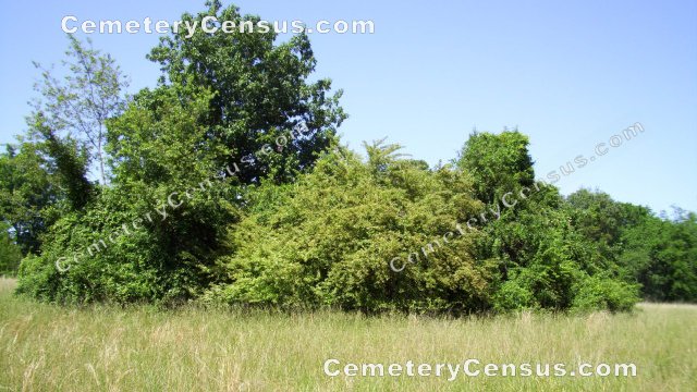
In 1991 Murray Parker reported the site. The site was visited and photographed by Glenn Lazarus on 11 May 2012. The heavily-overgrown site is located in a pasture. In 2021, a survey was conducted of parcel 75457 and corrected coordinates for the cemetery were provided.
Owner: Claire Parker Wilson.
Legal Description: Parcel 75457. Estate book 08E/355. Plat 33-98. Newer plat 2021-214-shows both incorrect (2012) and correct location of the cemetery.
Topo Quadrant: Farrington.
Family owned: Yes.
Abandoned: Yes.
Number of graves: 15-20.
Approximate size of cemetery: 60'x75'.
Type: Unknown, but traditionally described as a slave cemetery.
Restricted access: Yes. Private property.
Condition: Overgrown and not easily identifiable.
Enclosed: No.
Markers present: Yes. Not inscribed.
Markers damaged by farming operations.
Hazards: The cemetery is very heavily overgrown with trees, shrubs and vines.
Listed: Yes. Gravesites of Chatham County.
Other information: The property owner's uncle, Donald Parker, farmed the land and recalls about 15 headstones. A neighbor, Joyce Kachergis's daughter Ann, recalls at least 20 headstones, some with inscriptions that she tried to make rubbings of as a child. Only three fieldstone markers could be located by Glenn Lazarus when he visited in May 2012 due to the extremely overgrown condition of the site. Property owner Donald Parker accompanied the surveyor who created the 2021 plat. The notes on the plat made by the surveyor say that several unmarked stones and depressions were found in the corrected location. It was suggested that the number and location of graves should be determined by a professional in that field of study.
Miscellaneous information: The site was reported to CCHA in 1991 by Murray Parker.
Last canvassed by: Glenn Lazarus, 11 May 2012; Donald Parker and surveyor Richard Ellis Bullock, Jr., 18 Jun 2021.
 Unknown, Unknown (b. Unknown - d. Unknown) Unknown, Unknown (b. Unknown - d. Unknown) fieldstone marking unknown grave.
- Unknown, Unknown (b. Unknown - d. Unknown)
fieldstone marking unknown grave.
- Unknown, Unknown (b. Unknown - d. Unknown)
fieldstone marking unknown grave.
Web page updated 7 June 2025
Index of All Cemeteries Alphabetical Index of All Burials Previous Page
|
|
 |