Index of All Cemeteries Alphabetical Index of All Burials Previous Page
Use the following to search across all the cemeteries listed.
Example: "Smith, Roger" (yes, use the quotes)
107 CHEEK AND WHITAKER FAMILY CEMETERY (CA. 1836 OR EARLIER)
Location - In Chapel Hill Township about 750 ft. WNW of the end of that portion of Hatch Road (SR #1944) which is north of Hwy 54, west of Carrboro about 1.3 miles from the Hwy 54-Old Fayetteville Road (SR #1937) intersection. Private property.
Coordinates: 35d 55m 50.0s N; 79d 07m 18.0s W Click here for Online Maps
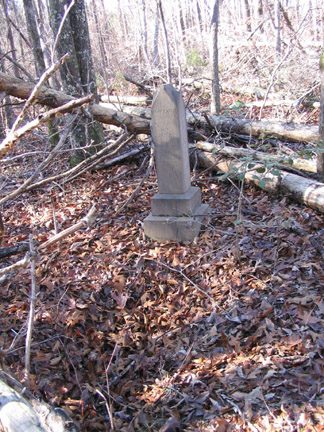
Survey - Beatrice B. Doak assisted Mary Claire Engstrom in the survey of this cemetery on November 13, 1972. Visited and photographed in January 2005 by Milton Forsyth, who also updated the directions. Panoramic view of entire cemetery. 1972 Plat of cemetery. 2005 Aerial view of cemetery location.
Comment - From the circle at the end of Hatch Road walk west about 75 ft down what appears to be the driveway for the house at 1500 Hatch Road (but is actually a gravel road mentioned again below). The old wagon road, a six-foot wide, two-foot deep ditch, goes off NW and swings west. The distance is about 1/4 mile on the wagon road to the cemetery which sits next to the road on the north side. Comment: In 2005, movement thru the wooded area was difficult due to a number of fallen trees, possibly from the hurricanes of the 1990s. The entrance to the wagon road appears blocked and an approach from the lawn area of the house to the north of the circle may be preferred. Or, if one goes west from the circle on the gravel road mentioned above that looks initially like a driveway, this road turns north and ends at a large new silver-colored Quonset hut. The cemetery is 110 ft NNW (330 degrees) from the NW corner of this structure. This latter area is owned [in 2005] by the people who reside at 1500 Hatch Road. The cemetery is on woodland north of their property line. It might be advisable to seek their permission to cross their land
Graves, Marked - There were 2 marked graves in this cemetery.
Graves, Unmarked - There were a total of 40 unmarked graves in this cemetery, and 4 unmarked depressions, although this number is uncertain.
Current Status - the 60' X 62' cemetery is unenclosed and unkempt. Whitakers as well as Cheeks are said to be buried there although there is no evidence of it. There appear to be 42 graves although this is uncertain. A relatively new obelisk marks the grave of Mary Cheek. The old stone evidently is the Mary Cheek stone lying on the ground nearby. Uninscribed fieldstones of slate and shale and rocks mark 35 graves; there are 4 unmarked depressions. (In 2005 a portion of the cemetery was covered with fallen trees. Access in the summer is probably difficult due to vegetation).
 Cheek, J. R. (b. 3 Nov 1834 - d. 3 Jul 1836) Cheek, J. R. (b. 3 Nov 1834 - d. 3 Jul 1836)  Cheek, Mary (b. 11 Jun 1805 - d. 10 Jan 1863) Cheek, Mary (b. 11 Jun 1805 - d. 10 Jan 1863) Aged 57 Yrs., 6 Mos., 29 Ds. 'Yea, saith the Spirit. That they may rest from their labours: and their works do follow them.' Footstone: M.C. footstone
- Cheek, Mary (b. - d. 31 Dec 1867)
Wife of W M Cheek Was Bournd June 11 Ja. 1 1 68(?)
Web page updated 15 April 2021
Index of All Cemeteries Alphabetical Index of All Burials Previous Page
|
|
 |

)
)
)